|

| Main Menu | |||||||
|
|||||||
| Presentations | |||||||
|
|
|||||||
Interests and activites |
Amateur Band Conditions |
||||||||||||||
WSPR
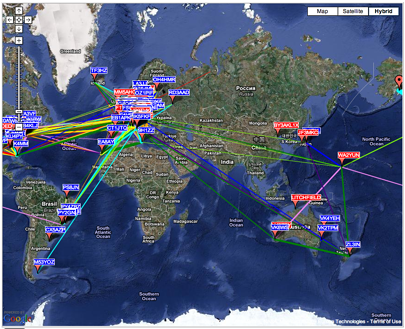
Screen shot of wspr map downloadable from Propagation Map WSPRR and Program Download Here WSPR implements a protocol designed for probing potential propagation paths with low-power transmissions. Normal transmissions carry a station's callsign, Maidenhead grid locator, and transmitter power in dBm. The program can decode signals with S/N as low as -28 dB in a 2500 Hz bandwidth. Stations with internet access can automatically upload their reception reports to a central database called WSPRnet , which includes a mapping facility. To see a live version of the map pictured at top right, click here
. |
|
||||||||||||||
|
|
|||||||||||||||


Page updated 2/1/2010